
The Ultimate Serengeti National Park Map & Guide
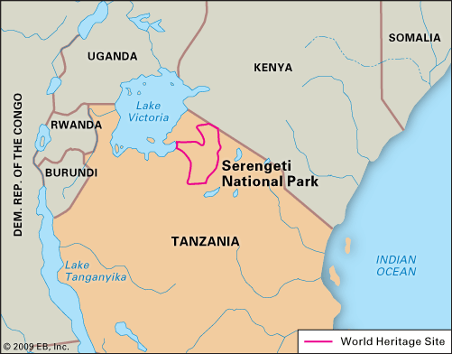
The Serengeti National Park map covers 14,750 square kilometers in northern Tanzania, bordering Kenya’s Maasai Mara. On a map of Africa, it is located just south of the equator, east of Lake Victoria. The map of Serengeti National Park is divided into four distinct regions: the Southern Plains, Central Serengeti, Western Corridor, and Northern Serengeti.
Where is the Serengeti Plain on a Map of Africa?
When travelers ask where is the Serengeti plain on a map, they are looking at one of the most iconic geographical features on the continent.
- Continent: Africa (East Africa)
- Country: Tanzania (with the ecosystem extending north into Kenya as the Maasai Mara)
- Coordinates: Approximately 2° to 3° South latitude, 34° to 35° East longitude.
- Landmarks: On a map of Serengeti plains, you will see it bordered by Lake Victoria to the west, the Ngorongoro Conservation Area to the southeast, and the Kenyan border to the north.
4 Key Regions of the Serengeti
To truly understand the serengeti national park tanzania map, you must know its four primary ecological zones. Your safari itinerary will depend entirely on which of these regions you visit:
Region on the Map | Key Landmarks & Camps | Best Time to Visit & What to See |
|---|---|---|
Southern Serengeti | Ndutu, Naabi Hill, Moru Kopjes | Jan – Mar: The calving season. Short-grass plains where 400,000+ calves are born, attracting massive cheetah and lion populations. |
Central Serengeti | Seronera River Valley, Seronera Airstrip | Year-Round: The geographic heart of the park. Famous for year-round resident wildlife, especially leopards in the sausage trees and cheetahs on the plains. |
Western Corridor | Grumeti River, Lobo, Fort Ikoma | May – Jul: The herds migrate northwest, facing their first major crocodile-infested river crossing at the Grumeti River. |
Northern Serengeti | Kogatende, Mara River, Lamai Wedge | Jul – Oct: The dramatic climax. The herds brave the Mara River crossings before pushing into Kenya’s Maasai Mara. |
Navigating the Map for the Great Migration
Understanding the map of the serengeti national park is the secret to successfully tracking the herds. The migration is a continuous, clockwise loop, meaning the “best” location on the map changes every month.
- To witness the beginning of the cycle in the nutrient-rich south, you must position yourself in the Ndutu region. Learn how to track the herds across this vast landscape with our expert guide to the Serengeti wildebeest migration.
- To secure front-row seats at the dramatic northern river crossings, expert routing is essential. Book a custom Serengeti wildebeest migration safari with our local guides who use real-time radio networks to pinpoint the herds’ exact location on the map.
Extending Your Map Beyond the Serengeti
The serengeti national park map is just the beginning of your Tanzanian adventure. The country’s northern circuit is highly interconnected, allowing for seamless multi-destination itineraries.
- The Ngorongoro Extension: Located just southeast of the Serengeti on the map, the Ngorongoro Conservation Area is a must-visit. Descending 600 meters into the caldera for a ngorongoro crater safari guarantees exceptional Big Five density, including the endangered Black Rhino, in a single day.
- The Coastal Finale: After days of navigating the vast savanna, look east on the map toward the Indian Ocean. We handle all domestic flight logistics for travelers Visiting zanzibar, transitioning you from the dusty plains to pristine white-sand beaches, spice tours, and historic Stone Town. Start planning your idyllic, stress-free coastal extension by Visiting zanzibar.
Frequently Asked Questions (FAQs)
Q: Where is Serengeti National Park on a map?
A: On a map, the Serengeti National Park is located in northern Tanzania, East Africa. It shares its northern border with Kenya’s Maasai Mara National Reserve and sits just east of Lake Victoria, covering 14,750 square kilometers.
A: On a map, the Serengeti National Park is located in northern Tanzania, East Africa. It shares its northern border with Kenya’s Maasai Mara National Reserve and sits just east of Lake Victoria, covering 14,750 square kilometers.
Q: Where is the Serengeti plain on a map of Africa?
A: The Serengeti plain on a map of Africa is found in the eastern part of the continent, just south of the equator. It spans the border region between northern Tanzania and southwestern Kenya.
A: The Serengeti plain on a map of Africa is found in the eastern part of the continent, just south of the equator. It spans the border region between northern Tanzania and southwestern Kenya.
Q: How big is the Serengeti National Park on a map?
A: The map of Serengeti National Park covers a massive 14,750 square kilometers (5,700 square miles). To put this in perspective, it is nearly 10 times larger than Kenya’s Maasai Mara, which is why it offers a much more exclusive, crowd-free safari experience.
A: The map of Serengeti National Park covers a massive 14,750 square kilometers (5,700 square miles). To put this in perspective, it is nearly 10 times larger than Kenya’s Maasai Mara, which is why it offers a much more exclusive, crowd-free safari experience.
Q: Can I see the whole Serengeti map in one trip?
A: While the park is vast, a well-planned 5 to 7-day itinerary allows you to traverse the map from the Central Serengeti (Seronera) to either the Southern Plains (for calving) or the Northern Serengeti (for river crossings), depending on the season.
A: While the park is vast, a well-planned 5 to 7-day itinerary allows you to traverse the map from the Central Serengeti (Seronera) to either the Southern Plains (for calving) or the Northern Serengeti (for river crossings), depending on the season.
Ready to Navigate Your Perfect Tanzania Safari?
Don’t leave your route to chance or generic booking aggregators. Our local, TATO-licensed experts specialize in crafting bespoke, transparently priced itineraries that position you in the exact right region of the serengeti national park map for your travel dates.
